Geophysical Applications

Geophysical Applications

Our geophysical applications determine the depth and precise location of the unseen features below the ground or pavement surface, non-invasively, without the destruction, disruption, and risks as typically associated with traditional exploratory methods. We have the experience to effectively adapt to complex industrial environments which present cultural interference limitations to geophysical applications.

Geophysical capabilities include the search and detection of a variety of natural and buried non-metallic and metallic (ferrous and non-ferrous) subsurface features.

We use a broad diversity of technically advanced, reliable, accurate and portable instruments to achieve the objectives of your specific project.
Alabama Geophysical Applications

We specialize in the applications of:

Subsurface Utility Engineering (SUE)

Are you planning a feasibility study to determine if a project is practical? Are you in the design phase of a project? Consider our non-invasive subsurface search, detection, and mapping services. 

Our Geophysical Surveys are performed in accordance with the ASCE 38-02 quality levels as outlined in the “Standard Guideline for the Collection and Depiction of Existing Subsurface Utility Data”.

We perform pre-project deployment research of available records pending specific project objectives, this information integrated with our field results for comprehensive depiction of the subsurface environment. We provide comprehensive and accurate documentation of site-specific civil features and interpreted subsurface detected features based upon geophysical technology responses and land survey of field markings, all in accordance with ASCE 38-02 guidelines. We provide detailed and descriptive scaled plats.  

Concrete Examinations

Before concrete coring or saw cutting, consider our non-invasive subsurface search, detection, and mapping services. Our geophysical concrete examinations have been performed in diverse environments, from the lower levels of sanitary sewer lift stations, to the top floors of skyscrapers.

We utilize the most advanced subsurface interface radar systems to locate:

  • Steel reinforcement (mesh, rebar)
  • Conduits
  • Post-tension cables
  • Pre-tension cables
     

Locations and depths of embedded features are marked and indicated upon the concrete surface.

Geologic/Environmental

Our geologic geophysical surveys have been effective by: 

  • Determining soil stratigraphy 
  • Delineating sinkhole formations in karst terrains 
  • Detecting subsurface voids/cavities 

Deliverable products include contoured and labeled subsurface imaging.


Performing an environmental site assessment? 

  • Determine safe boring locations 
  • Locate Underground Storage Tanks (UST) 
  • Delineate landfills 
  • Delineate isolated contamination plumes 

Archeological Cultural Resource

Locate and delineate unmarked burial graves and archeologically significant cultural resources.

Submittals include: 

  • Descriptive reports 
  • Scaled color plats for client interaction 

Using unsurpassed metal detection and subsurface imaging technologies, E.F. Thompson Geotechnologies, Inc. is highly experienced in the search, detection, and mapping of Unexploded Ordinance (UXO).

Pavement and Bridge Examinations

Comprehensively evaluate infrastructure such as roads, parking areas and bridges with our geophysical examination services. The results of our geophysical pavement examinations provide detailed information and are depicted on scaled color plats for client interaction. Our geophysical examinations are performed non-invasively with ground penetration radar (GPR) and provide the ability to effectively strategize pavement rehabilitation or repair projects.

Utilize our services to locate and map:
  • Dowel bars
  • Corroded rebar
  • Asphalt thickness
  • Pavement distresses

Geophysical Consulting

Is your industrial facility contemplating an excavaction? Are your current pre-excavation procedures and dig evaluations effective? Keep workers SAFE and PREVENT UTILITY DAMAGE.

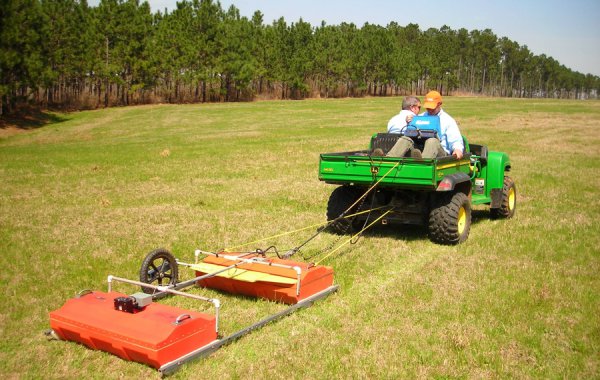
Backed by over 29 years of non-invasive subsurface search, detection and mapping experience, E.F. Thompson Geotechnologies, Inc. develops:

  • Comprehensive Procedures
  • Excavation Safety Awareness
  • Subsurface Utility Damage Prevention
  • Risk-Cost Assessment
  • Referenced Industry Standards